Please be aware when registering, all times are in the Eastern Time Zone. Even for free events, you will need to click the "Proceed to Checkout" button and "Submit Order"
to complete your registration. If you do not receive an automated confirmation email, or if you have any questions about registration, please email
onlineseminars@saa.org.
Registration Closed!
Beyond Mapping Grade: Using High-Precision GNSS Tools for Archaeological Site and Project Mapping
When: September 19, 2017 2:00-4:00 PM ET
Duration: 2 hours
Certification: RPA-certified
Pricing
Individual Registration: $99 for SAA members; $139 for non-members
Group Registration: $139 for SAA members; $179 for non-members
Fred Limp has been involved in the applications of GPS (now GNSS) for more than two decades with experience in a wide range of navigation, mapping and survey GNSS hardware and software systems and with a special focus on archaeological and heritage applications. For 10 years he has taught advanced undergraduate and graduate courses in GNSS principles and applications at the university level. Recent applicable efforts involve detailed cost/performance comparisons of a range of systems and the development of workflows making GNSS, and especially high precision RTK solutions, more user friendly.
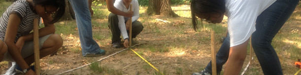
New developments in high precision GPS (also known as Global Navigation Satellite System or GNSS) systems now provide the capability to perform rapid (a few seconds per measurement) and precise (better than 5 cm) archeological mapping over large areas. Lower precision GNSS “mapping systems” have been long used to locate sites within a survey but these newer approaches can be used to provide detailed mapping of feature and architectural elements, individual artifacts, and other object locations. The new GNSS systems—often referred to as “real time kinematic” or RTK—can replace, or augment, traditional electronic distance measurement mapping tools and are especially valuable in sites that cover large areas. This online seminar will compare the traditional mapping grade systems with the new RTK based ones; review the strengths/weaknesses and cost/benefits of the systems; and provide specific high-precision workflows relevant to archaeologists. This course is designed for archaeologists with previous experience in mapping grade GNSS who are interested in improving the speed and precision of their mapping work.
- Compare the traditional mapping grade systems with the new RTK based ones;
- Review the strengths/weaknesses and cost/benefits of the systems; and
- Provide specific high-precision workflows relevant to archaeologists