| Historical Research Techniques | Preparing for the Field | Data Recovery | In the Lab | Preserving Collections |
The methods used by archaeologists to gather data can apply to any time period, including the recent past. One archaeologist in the U.S. has become known for his study of the garbage discarded by the people of Tuscon, Arizona in the 1970s! This "garbology" project proved that even recent artifacts can reveal a lot about the people who used and discarded them.
Over the past 150 years, archaeologists have developed effective methods and techniques for studying the past. Archaeologists also rely on methods from other fields such as history, botany, geology, and soil science.
Historical Research Techniques
Archival research
Archival research is often the first step in archaeology. This research uncovers the written records associated with the study area. If people lived in the area when there were written records, the archaeologist will look for associated primary historical documents. This archival research may take the archaeologist to public or university libraries, the local historical society or courthouse—or even into people’s homes! Primary documents could include: maps and/or photographs of the area, newspapers, land and tax records, and diaries or letters.
In addition to primary historical documents, archaeologists will look for site reports that other archaeologists have written about this area. These reports will describe what the archaeologist found in this area during any previous investigations. These older site reports can help guide the new research. The State Historic Preservation Office maintains documentation files for all the recorded archaeological sites in each state. This will include previous archaeological research reports about sites in the state.
Oral History
Oral history is another research method that archaeologists and historians may use to gather information. It includes information passed down by word of mouth. Stories passed down about your family history and traditions that your family observes are oral history.
Archaeologists today collaborate with descendants to better understand the cultural traditions of their pasts. Archaeologists working on the 19th-century Levi Jordan Plantation in Texas interviewed descendants. They included both descendants of the plantation owners and of the enslaved plantation workers as part of their research. These archaeologists wanted to include the voices and perspectives of all the past peoples who lived and worked there. At Castle Rock Pueblo in southwestern Colorado, archaeologists used oral history. Through the oral traditions of modern Puebloan people, they learned about the past culture of their Anasazi ancestors.
Preparing for the Field
While historians and archaeologists both use written documents to learn about the past, only archaeologists interpret archaeological sites. That involves unique field work.
Tools of the Trade
You may think of shovels when you think of digging, but the most important piece of equipment in the archaeologist’s toolkit is the trowel. Archaeologists use trowels to scrape away thin layers of soil from test units, or holes in the ground. Of course, archaeologists use many other tools in the field and lab. They need equipment to dig, sift, measure, and analyze artifacts. Some, like Scanning Electron Microscopes (SEM) are very specialized. Others, like tape measures, toothbrushes, and dustpans, are everyday objects!
How Do You Find Sites?
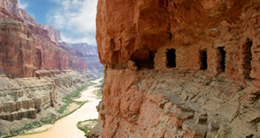
Archaeologists use different methods to find sites—surveying the ground, using satellites, or sometimes by accident! An observant beach walker discovered the prehistoric burials at Low Hauxley on the coast of England. A stone box had been sticking out of a sand dune after a storm. Construction workers discovered a burial ground with remains of more than 400 17th and 18th-century Africans during construction in New York City. The African Burial Ground is now a National Monument because of its significance in American history.
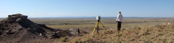
An archaeological predictive model is a tool that indicates the probability that an archaeological site exists in a certain area. It helps determine where archaeologists look for sites based on factors like distance from water, ground steepness, soil type, and other factors that influence where people settle or perform certain tasks. The methods used to find sites will depend on the kind of research questions that the archaeologist is trying to answer. If there are plans for highway or housing construction, archaeologists may need to know of any archaeological sites on the property. First they will check if there were any previous surveys in the area and, if so, what the results were. If there are no previously recorded sites, the archaeologist will conduct an archaeological survey.
If there are sites, the archaeologist will want to know how many, their locations, and how the sites relate to each other. Usually, to save time and money, the archaeologists only test a sample of the area.
Surface Surveys
A surface survey is a systematic examination of the land. A team of archaeologists will walk in straight lines back and forth across the study area. As they walk, they look for evidence of past human activity, including walls or foundations, artifacts, or color changes in the soil that may indicate features. They will use a compass and long tape measure to make sure they walk in a straight line and will record the exact location of all evidence they find. They collect any artifacts and put them in bags with a label of their exact location. Features on the surface, which they cannot remove, are photographed and drawn.
Shovel Test Pits
Shovel test pits (or STPs) are a series of narrow holes dug in an area that archaeologists believe to be a potential site, revealing artifacts or features. Archaeologists usually dig test pits where the ground has not been farmed or plowed and it contains a lot of surface vegetation. They may screen (sift) the soil to recover small artifacts and often draw profiles of the test pits to record what the soil looks like in each hole.
Geophysical Surveys
There are non-invasive techniques archaeologists can use to find sites without digging. Examples of geophysical surveys that do not disturb the soil include magnetometry, resistivity, and ground-penetrating radar.
Evaluating Site Significance
After conducting a survey, archaeologists will have enough information to determine if any significant archaeological sites are in the study area. They may or may not find a site. Or, the sites may or may not be "significant" as defined by the law in the National Historic Preservation Act. Regardless, the archaeologist will write and file a site report with the State Historic Preservation Office, which describes their research. If they found significant sites, they might plan further excavations.
Data Recovery
Believe it or not archaeologists rarely excavate (dig) entire sites! Archaeology is a destructive science—meaning that once a site is excavated, it is gone forever. The artifacts and information gathered remain, but the site itself can never be recreated. Excavating sites is also costly and time-consuming. Once the dig is done, archaeologists have a professional responsibility to analyze all the artifacts and information obtained, to report on their research, and to curate the collections. For these reasons, archaeologists generally excavate only when there is a threat of destruction or when they may reveal vital information about past cultures. And they usually excavate only a small part of any site.
Although archaeologists work on all kinds of environments around the world, they follow the same basic process when planning an excavation.
Research Design
Before an excavation begins, archaeologists write a research design. This outlines the "who, what, where, when, how, and why" of the fieldwork. Archaeologists must submit this important document for review before gaining permission to excavate a site. In the U.S., the State Historic Preservation Office reviews this plan. If an American archaeologist wants to work in a foreign country, permission must be granted by the appropriate agency in that government. Tribal (American Indian) lands in the U.S. have their own review processes, and some tribes have their own archaeology programs that control access to sites on tribal lands. Once a research design receives approval and permits, a team gathers the necessary people and tools.
Gridding the Site
Archaeologists must record the exact location of all artifacts and features on a site. Before removing any soil or artifacts from a site, they create a site grid. They establish a datum point, or fixed reference point for all measurements. Then they superimpose a rectangular grid over the whole site. They measure each square in the grid and assign it a number. These squares are often referred to as units. This system allows the archaeologist to create a precise map and to record the exact location of all the features and artifacts on the site.
Excavating a Unit
Archaeologists use a statistical sampling method to select which squares or units they will excavate. To begin, they will collect surface artifacts, then remove any ground vegetation. Archaeologists screen all soil removed from a unit to recover small artifacts and ecofacts. They record exact location, both horizontally and vertically, of all materials recovered. They store artifacts from each unit in secure bags labeled with the site and excavation unit numbers and level. The unit may be dug in arbitrary levels (such as every 10 cm) or by following the natural stratigraphy (layers) of the soil.
Stratigraphy
Stratigraphy is the study of geological or soil layers. Over time, both natural processes like the decay of organic matter, and cultural processes (caused by humans), create soil layers. The cross section of these soil layers resembles a layer cake. The oldest layers are on the bottom and the most recent layers are on the top. This is called the Law of Superposition and is one of the most important principles in archaeology. Archaeologists can use stratigraphy to determine the relative age of each layer and its contents.
In the Lab
Archaeologists spend much more of their time in the laboratory analyzing artifacts and data than they do in the field. Archaeologists analyze artifacts, features, and other information recovered in the field to help answer their research questions. During the investigative process, they might seek to learn when people occupied the site, the purpose of the objects recovered, what the people ate, the kinds of structures they built, with whom they traded, and much more. They may also look at how the site they are analyzing relates to other sites. The analysis will depend on the archaeologist's research questions from the beginning of the project.
How Old is it?
There are a variety of techniques for determining the age of an artifact or archaeological site. Stratigraphy can determine the relative age of soil layers and artifacts and can help us understand the order of events. But if an artifact of known age (such as a coin with a mint date) is found in a soil layer it can tell us when something occurred. Tree-ring dating, or dendrochronology, is one of the oldest dating methods used by archaeologists. It is based on the principle that trees produce growth rings each year and the size of the rings will vary depending upon rainfall received each year. Archaeologists have built up long sequences of rings from tree trunks that extend back centuries. In the American Southwest, tree ring dating goes back to 59 BC. Radiocarbon (C14) dating is the most popular method to date objects made of organic matter. Potassium-argon dating can date ancient objects—up to 100,000 years old. Obsidian hydration can date artifacts made from volcanic glass. This is only a sample of the many physical and chemical dating methods that archaeologists use to date archaeological sites and artifacts.
Analyzing Artifacts
Artifacts are important sources of information for archaeologists. Artifacts can tell us about the diet, tools, weapons, dress, and living structures of people who made and used them. Archaeologists wash, sort, catalog, and store recovered artifacts after bringing them back from the field. They analyze individual artifacts, but also may sort them into groups to see patterns. For example, they might weigh all the oyster shells together or count all the nails and consider them as one unit. The locations of artifacts on the site provide clues to the kinds of activities that occurred. The type of material the artifact is made of is another important piece of information. It that can inform whether past people obtained the materials locally or by trading with another group. Artifacts provide a window into the lives of peoples who lived before.
Analyzing Features
A feature represents human activity but, unlike most artifacts, it cannot be removed from the archaeological site. A feature might be a stain in the soil that is evidence of a former fence post. Photographs, drawings, and soil samples of the fence post hole collected by the archaeologist are part of the scientific record of that feature. Those documents and samples are just as important as the artifacts found nearby. Features like soil stains can reveal the outlines of prehistoric or historic structures such as houses, barns, longhouses, and earthen lodges. Other types of features include hearths (fire pits), storage pits, and middens—what archaeologists call garbage dumps! Privies (outhouses) are important features in historical archaeology sites, because people used to dump their garbage into them.
Preserving Collections
Archaeologists have both ethical and legal obligations to preserve all the data they collect for the benefit of future generations. This includes not just the artifacts recovered, but also the associated information and records. This includes soil samples, field notes, maps, photographs, drawings, and related historical documents. Archaeologists follow strict guidelines and procedures for cleaning, labeling, cataloguing, and storing objects.
Where are Collections Stored?
Each state has a responsibility to store the millions of artifacts recovered from surface collections or excavations within its boundaries. Finding space for these collections is a major challenge. While some collections are stored in many locations around the state, other states have created centralized archaeology storage facilities.
Universities and museums also sponsor archaeology projects and are responsible for preservation and storage. Archaeologists working at museums or universities may store their collections there. The University of Pennsylvania Museum of Anthropology and Archaeology in Philadelphia is an example of a museum with important archaeology collections, which it stores, displays, and loans to other institutions for exhibitions. These collections are also studied by scholars from all over the world. At the Smithsonian Institution’s Department of Anthropology, located in the National Museum of Natural History, archaeologists store their collections at the museum on the National Mall and nearby storage facility.
Why Are Collections Preserved?
We preserve collections for both scientific research and public education. The application of new technologies and dating techniques to old collections yields valuable new information that may lead to new understandings about our human past. For instance, neutron activation analysis now allows us to trace the origin of the raw materials used in Maya ceramic pots, collected over a hundred years ago. Both DNA analysis and atomic mass spectrometry (AMS) radiocarbon dating are being applied to plant and animal remains to study the origins of domestication.
Archaeological collections are also preserved for use in museum exhibits so that the public may benefit from the archaeological research that unearthed them. This way, we can all connect to the work that archaeologists do.